

හිරු පායලා ඉවර වෙනකොට හයත් පහුවෙලා. අපි 7.30ට විතර වන්දනා මග දිගේ පහළට බහින්න පටන් ගත්තා රත්නපුර දිහාට. මේ කඳු මුදුනේ තියන අඩි 1,500ක විතර උස කේතුකාර ගල් පර්වතය ඇත්තටම සෑහෙන්න බෑවුම්. මම පැති කිහිපයකින්ම ඒ දිහා බලලා තියනවා. ඒ හැම පැත්තෙන්ම මේ කඳු මුදුන අංශක 900ට වඩා අඩුයි.
වන්දනා පථය ඔස්සේ පහළට
මේ කොටසේ නම් පහළට කරුණා කරන්න හැම පඩියක්ම කපලා තියනවා. යන්න අමාරු හැම තැනකම දම්වැල් වාරු එල්ලලා තියනවා. එහි එක් පුරුකක් අඟල් හයක් විතර දිගයි. හැම ජාතියකම දම්වැල් අපූරු විදිහට තනලා තියනවා. සියවස් සෑහෙන ගාණක් පැරණි ඇති. පිළිවෙළින් ආපු පරම්පරා ගණනාවක වන්දනාකරුවන්ගේ සැදැහැවත් ත්යාගයන් ලෙස මේවා සලකන්න පුළුවන්.
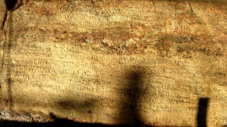
අතරින් පතර, සිංහල අකුරු වලින් ලියවුනු දීර්ඝ ශිලාලේඛනයන් පර්වත මුහුණතේ දැකගන්න පුළුවන්. හැම තැනකම වගේ මුළු ගමන් මඟ දිගේම අවුරුදු ගානක් තිස්සේ පිළිවෙළින් ආපු සංචාරකයන්, කපමින් කොටමින් හැඩ කරමින් මග සකස් කරමින් දක්වපු අපරිමාණ ශ්රමයක ලකුණු විදහා දැක්වෙනවා.
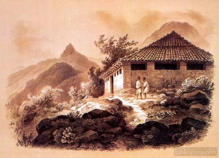
පහළ ඉඩකඩ ඇති තැන් වල තනා තියන නවාතැන් පොළවල් සහ ගිමන් හල් ගැන සඳහන් කරන්න අමතක කරන්නම බැහැ . කොහොම නමුත් මේවා සෑහෙන්න ජරාවාසයට පත් වෙලා. ඇත්තටම නූතන ලෝකයේ හැටියට මේ ස්ථානය දැක්කම යමෙකුට හැඟෙන්න පුළුවන් ශ්රී පාදයට කරපු අවනම්බුවක් විදිහට. නමුත් එය නඩත්තු කරන්න ඉන්නෙත් සමාජයේ ඉන්න ඉතා දිළිඳු සහ නූගත් අය විතරයි.
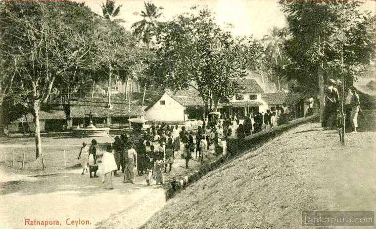
රත්නපුර මුහුදු මට්ටමෙන් අඩි 150ක් විතර උස, සිරිපා කඳු මුදුනේ ඉඳන් සැතපුම් 24ක් විතර දුරකින් පිහිටි, ඊට කෙළින්ම පිටිපසින් පිහිටි පහසුවෙන් හඳුනාගත හැකි නගරයක්. මහ කැළෑව අතරේ ගල් පර්වත පසු කරමින් තමයි එහාට යන්න වෙන්නේ. පාරක් තොටක් කියලා කිසිදෙයක් නැහැ. පල්ලම් බැහැපු අඩි 7,000ම වගේ සම්පූර්ණයෙන්ම පළාබද්දලට ගිය පළමු සැතපුම් දොළහ ඇතුලතදි සිද්ධ වුනා. කන්ද පාමුලම වගේ ඉතා කුඩා ගම්මානයක් තිබුනා.
මම දන්නේ නෑ මේ වගේ පල්ලම් බැහැලා මේ වගේ තෙහෙට්ටුවක් මට මීට කලින් දැනිලා තියනවද කියලා. සැකයක් නැතිවම පංගුවක් තෙහෙට්ටුව කලින් දවසේ උදේයි රෑයි ලබාපු අත්දැකීම්. අනික් පංගුව දේශගුණයෙන් ඇතිවෙච්ච බෙලහීන කම හන්දම ව්යායාම කරන්න ඇතිවුනු ඕනෑකම.
ගමන් මග නම් අවදානම් සහිතයි. ඇත්තටම මේ කඳු නැගීම නම් වන්දනාවක්ම තමයි. විශාල පියවර තබමින් ගලින් ගලට මුලෙන් මුලට ඈතින් පය තබමින් කෙළින්ම කන්ද උඩටත් ආපසු පහළටත් යන මේ ගමන වන්දනාවක් නොවෙන්නේ කොහොමද? දිග අක්වක් වංගු පාරවල් නැතිව වෙන දිග පාරවල් නැතිව යන මේ ගමන ඒවා තිබුනා නම් පීඩාව සෑහෙන දුරට මගහරවා ගන්න තිබුනා. ඒ වුනත් ගමන නම් සෑහෙන්න සිත්ගන්නාසුළුයි.
“ආදම්ගේ ශිඛරය මතින් එලිෆන්ටා ගුහා වෙත – ලක්දිව සහ ඉන්දියාවේ රූප සටහන්” : එඩ්වඩ් කාපෙන්ටර්
සිව්වන පරිච්ඡේදය : සිරිපා ශිඛරය හා කළු ගඟ
From Adam’s Peak To Elephanta : Sketches in Ceylon and India by Edward Carpenter
CHAPTER IV: ADAM’S PEAK AND THE BLACK RIVER.
The sun rose soon after six, and at 7.30 we started downwards, on the great pilgrim-track towards Ratnapura. The final cone, for about 1,500 feet, is certainly a steep bit of rock. I have seen it from several points of view, but the summit angle was always under 90°. Steps are cut nearly all down this part, and chains hang alongside in all places of possible difficulty—chains upon chains, things with links six inches long, all shapes and curiously wrought, centuries and centuries old—the pious gifts of successive generations of pilgrims. Here and there are long inscriptions, in Cinghalese characters, on the rock-faces ; and everywhere signs of innumerable labor of successive travelers in hewing and shaping the path all the way—not to mention resting-sheds and cabins built in convenient spots lower down. These however are largely fallen to decay ; and indeed the whole place gives one the impression that the sripada has come some what Into disrepute in these modern times, and is only supported by the poorer and more ignorant among the people.
Ratnapura is only 150 feet or so above the sea ; and for twenty- four miles the path to it from the summit—well-marked but single file—goes down over rocks and through vast woods, without coming to anything like a road. Nearly the whole, however, of this great descent of 7,000 feet is done in the first twelve miles to Palabaddala—a tiny hamlet at the very foot of the mountains—and I don’t know that I ever felt a descent so fatiguing as this one, partly no doubt owing to the experiences of the day and night before, and partly no doubt to the enervation produced by the climate and want of exercise ; but the path itself is a caution, and the ascent of it must indeed be a pilgrimage, with its huge steps and strides from rock to rock and from tree-root to tree-root, and going, as It does, almost straight up and down the mountain side, without the long zigzags and detours by which in such cases the brunt Is usually avoided. All the same it was very Interesting
ලක්දිව ගමන් සටහන් පිටු අංක: 30

One thought on “Descent by the Pilgrim-Track”